


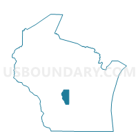
LEOLA - T 1 Voting District, Adams County, Wisconsin
About
Outline

Summary
| Unique Area Identifier | 692183 |
| Name | LEOLA - T 1 Voting District |
| County | Adams County |
| State | Wisconsin |
| Area (square miles) | 37.31 |
| Land Area (square miles) | 37.28 |
| Water Area (square miles) | 0.03 |
| % of Land Area | 99.92 |
| % of Water Area | 0.08 |
| Latitude of the Internal Point | 44.20312320 |
| Longtitude of the Internal Point | -89.66794040 |
Maps


Graphs
Select a template below for downloading or customizing gragh for LEOLA - T 1 Voting District, Adams County, Wisconsin


Neighbors
Neighoring Voting District (by Name) Neighboring Voting District on the Map
- BIG FLATS - T 1 Voting District, Adams County, WI
- COLBORN - T 1 Voting District, Adams County, WI
- GRANT - T 2 Voting District, Portage County, WI
- HANCOCK - T 1 Voting District, Waushara County, WI
- PINE GROVE - T 2 Voting District, Portage County, WI
- PLAINFIELD - T 1 Voting District, Waushara County, WI
- ROME - T 3 Voting District, Adams County, WI
Top 10 Neighboring County Subdivision (by Population) Neighboring County Subdivision on the Map
- Rome town, Adams County, WI (2,720)
- Grant town, Portage County, WI (1,906)
- Big Flats town, Adams County, WI (1,018)
- Pine Grove town, Portage County, WI (937)
- Plainfield town, Waushara County, WI (550)
- Hancock town, Waushara County, WI (528)
- Leola town, Adams County, WI (308)
- Colburn town, Adams County, WI (223)
Top 10 Neighboring Unified School District (by Population) Neighboring Unified School District on the Map
- Adams-Friendship Area School District, WI (14,638)
- Nekoosa School District, WI (9,138)
- Tri-County Area School District, WI (4,017)
Top 10 Neighboring State Legislative District Lower Chamber (by Population) Neighboring State Legislative District Lower Chamber on the Map
Top 10 Neighboring State Legislative District Upper Chamber (by Population) Neighboring State Legislative District Upper Chamber on the Map
Top 10 Neighboring 111th Congressional District (by Population) Neighboring 111th Congressional District on the Map
Top 10 Neighboring Census Tract (by Population) Neighboring Census Tract on the Map
- Census Tract 9612, Portage County, WI (6,036)
- Census Tract 9604, Waushara County, WI (3,456)
- Census Tract 9603, Waushara County, WI (3,249)
- Census Tract 9501, Adams County, WI (2,973)
- Census Tract 9502.02, Adams County, WI (2,674)